Holding Back The Tide
Projection using the team’s framework to assess possible flooding under certain conditions.
For leaders of coastal cities, addressing climate change means confronting an existential threat, as rising seas and stronger storms inundate critical infrastructure with increasing frequency. But even while the cost of doing nothing is too high, city officials around the world struggle to identify not just which protections are most useful to pursue, but also which among them are affordable.
A team of Columbia engineers is trying to help answer those questions, using New York City as a model. Armed with reams of data, recent experience of Hurricane Sandy, and insight from local government agencies, the researchers are creating a framework to take much of the guesswork out of creating smart defenses. “The goal is to have a tool that, in principle, optimizes coastal protection given a specific budget,” said Kyle Mandli, associate professor of applied mathematics. “One reason we picked New York was that the city is great about sharing data. In a lot of other countries, I wouldn’t be able to find a map of every building and what it’s made of.”
Since the fall of 2018, Mandli, along with George Deodatis, Santiago and Robertina Calatrava Family Professor of Civil Engineering, and Daniel Bienstock, Liu Family Professor of Industrial Engineering and Operations Research, have pored over those records and maps while deploying their students to interview stakeholders about Sandy’s toll on the city’s infrastructure, including the transportation network, power grid, and emergency services.
In collaboration with the National Center for Atmospheric Research, the team is constructing a set of computational models that urban planners will eventually be able to access for free. The models will recommend various protections, from restored wetlands and dunes to seawalls and even selective retreats, based on a given budget and topography.
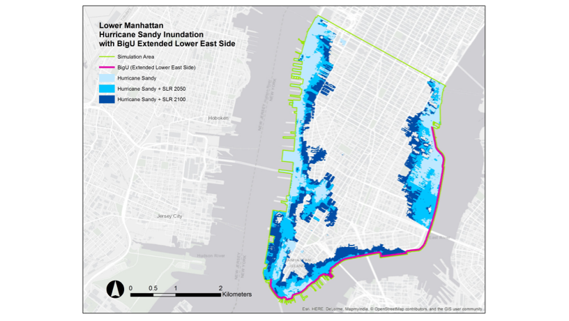
The devastation wreaked by Hurricane Sandy offers an instructive example, says Deodatis. In their New York City models, the team calculated a rise of 2 to 4 feet between 2050 and 2100 and 4 to 6 feet after 2100. Such an increase could turn even moderate hurricanes into highly destructive events. During Sandy, he said, the storm surged to 2.8 meters. If New York experiences sea level rise of a meter by the end of the century, a surge of only 1.8 meters would equal that of Sandy.
“Six feet of sea level rise will flood lower Manhattan if we do nothing,” Deodatis says. “The critical part is the coastline. If you can prevent water encroaching along the coastline by raising highways or building barriers, then lower areas inside the city won’t be affected.”
With this in mind, the researchers are examining impacts caused by the interdependence of infrastructure and services. For instance, loss of road access due to flooding can make it impossible for emergency personnel to reach victims or damaged buildings. Loss of power, meanwhile, can undermine a subway system and hospital services.
Deodatis called New York’s post Sandy-efforts to seal subway entrances and ventilation openings a prudent step against future hurricanes. And he notes a proposed series of raised parks around lower Manhattan coupled with a stormsurge barrier across the mouth of Lower New York Bay could make economic sense for preserving its Financial District. Whether these strategies are making use of limited funds in an optimal way, he notes, is precisely the sort of issue the group's research is designed to tackle.
Sometimes, however, a city may need to consider more even complex measures like strategic retreat. How to factor in the social and psychological cost of relocating entire communities is something they’ve begun exploring with the aid of psychologists, anthropologists, and other such experts.
The team hopes the tool will prove invaluable for urban planners from Miami to Mumbai, who could plug their inputs into the model as a key first step for generating solutions grounded in a local context.
“Having our methodology in place would save time for somebody doing the same analysis in another city,” says Bienstock.
Indeed, it’s smaller cities that might benefit the most, since they also have smaller budgets for both protection measures and the analysis required to choose between them.
“The computational costs to this kind of analysis are extremely high,” Mandli explains. “We want to create a tool that’s just as accessible to every small town in New Jersey as it is to New York City.”